Cycling in Senigallia, Italy: Defining characteristics found in Heuristic Evaluation
- Paulo Cantillano Lizana

- Aug 12, 2021
- 6 min read
Updated: Jun 1, 2022
Introduction
When we think of Italy we think of its delicious food, its magnificent historical monuments and its beautiful cities with narrow streets.
But Italy is much more than that. We must also think about bicycles; Despite not being among the countries with the largest number of kilometres built of bicycle lanes, Italy has had a boom in spaces reserved for bicycles long before the current pandemic, in 2016 there was already an increase of 22% compared to 2011 [1], however still there are many issues to face.
This study is based on the city of Senigallia, a touristic city located on the Adriatic Cost, it has a population of 44,183 inhabitants [2], which is highly representative of the Italian population, understanding that a 22% of the population live in cities between 20.000 and 60.000 inhabitants [3].
Senigallia has a not negligible number of riders, as the city’s characteristics allow its emerging as a real alternative to cars, having short routes to cover as the distances between the city centre and the activity centres is rather brief. However, the city does not have many cycle paths, mostly they focused on the seaside avenue and some discontinuous path in the newest neighbourhoods.
A specific route that connects the south neighbourhoods with the train stations has been analysed. There is no information about the number of daily riders circulating by this route, but a visual observation indicates is not a small amount as some streets within the path connects important places such as the dock, the market, the old city centre and the train station, which has a large number of bikes parked every day.
Street profile
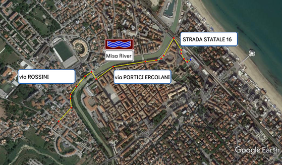
The riverside path is a set of streets that connect the south area of the city with the north side, where there are the beaches and also the stations. Precisely, the path chosen is from the residential south area, called Zona Ospedale, to the train station, located in the north side. It surrounds the main river that crosses the city, the Misa River and its made up by different surfaces such as asphalt, pavement, ground and cobblestones, its lengths is 1,2 kilometers but only 100 meters are defined as cycle path. The figure 1 shows the followed path.
Evaluation: Making principles explicit
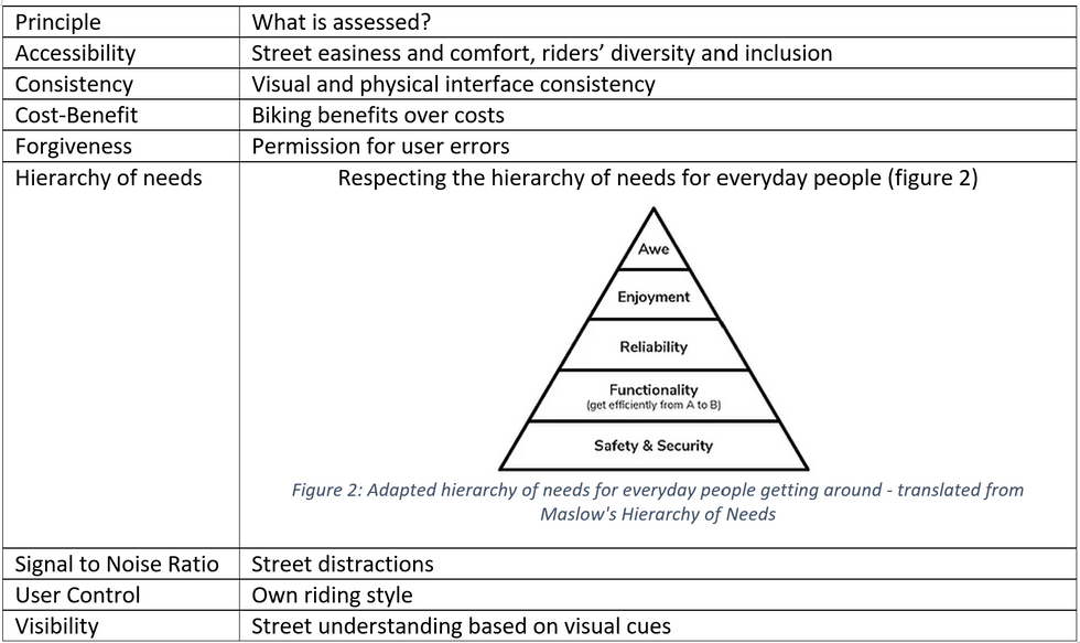
It is a method for finding usability flaws in the design, it takes the best practices usability principles and makes a brief evaluation of a user interface with the purpose of explicitly strong and weak points of a street’s usability for everyday bicycling.
This method has been applied in this case as it is easy to determine the level of the street by assigning ranking to each of the categories, which are already clearly determined.
This method is made up by 8 principles:
The assessment
The following assessment was done on a weekday during the peak morning hour, and conducted by three transport engineer, two on site and one by analysing the record and notes.
Accessibility: the path is not intuitive as most of this is not defined, then riders must choose between their safety or comfort.
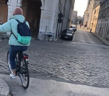
Consistency: As it was described, the route surface material is different along the road and also it presents a lot of imperfections and irregularities, especially in the cobblestone area (figure 3), there are areas where is not clear where to ride, street or sidewalk.
Cost-Benefit: For a large group of riders, the safety can outweigh the cost of parking a car in the city centre. People prefer using the cars for getting as much close to the city center as these parking lots are busy most of the time
Forgiveness: There is only segment that offers a partial forgiveness, and it is the one where the path is shared with the pedestrians, often riders stop for talking by phone or taking photos to the nice view of the river and the town that this spot offers. However, this is not replicate it at all along the path. Riders live a heavy and large stress when they must share the path with cars, especially on weekends when the parking is very high demanded. There is one segment where the riders must cross a heavy traffic road, this is mandatory as the option for pedestrians is under the street and is not accessible for all user and much less for riders
Hierarchy of Needs: Safety and reliability are not met in this path, as riders must interact with cars mostly in all the routes and even in the last part, near to the station, riders and cars must compete for the use of the lane in velocity, which is dangerous for riders. Beside this, it is never clear where the rider is allowed to run or not
Signal to Noise Ratio: Unfortunately, there are no signals to support riders.
User Control: Most of the riders adapt to the street conditions, however the different levels in surfaces cause a problem that not all riders solve in the same way (nor the same amount of energy). In the last segment, riders must adapt to the street conditions, such as high speed of cars and buses turning on the left
Strengths
The town is normally low-stress one, there are areas where it is really possible to express freely riding the bike, one of these areas belongs to this path and probably an intervention in the surface will not be so necessary. This low-stress is also reflected in the non-peak-hour times, as the traffic on the street is reduced significantly.
Main Issues
The main problem is what is not existing, that is, the cycle path. However this gives a great opportunity to do the right thing and the thing right. Summing up all the problems is clear that the path must fix the difference surfaces transitions, and also create connection with other segment of the street that does have a path for bicycles. It is important to understand the need of people for reaching the station as an important hub for multimodal trips, such as bus or train, and the need of the local authorities to provide a safety and reliable path for sustainable mode such as pedestrian or riders but evermore, an accessible path for all.
Conclusions
The city has a wonderful opportunity for improving the mobility as money investment can be reduced if the design is optimized in a way to intervene in the areas that currently has no large occupancy along the days; for example, the riverside sidewalk is not totally used as people (pedestrian) prefer to transit by the opposite sidewalk as it has shopping and restaurants. Also, and as it was mentioned, the city can boost the station as a hub, for this it would be necessary to make it more attractive for trips using soft mobility, a good outcome could be obtained by calming the area and allowing the cross by the surface.
On details, the recommendations pass through the following points:
Construction of cycle path on the west side of the riverside street, moving the parking. Currently there are more than 10 meters between sidewalks, and a well-thought distribution can fit either the parking lots as the cycle path along the sidewalks for pedestrians, allowing the coexistence of the 3 modes of transport and providing safety for each one.
Re-design of the area next to the station, calming down the traffic using tactical urbanism, allowing the crossing not only under but also on surface for pedestrian and bike. Providing accessibility and safety.
Installation of signal to aware the sharing of path with pedestrians, either vertical as horizontal ones
Increase the lighting of the path next to the riverside
Flattening the ground, avoiding irregularities
Leaving the south sidewalk of the bridge exclusive for riders, as cars have enough space and pedestrian can use the north side
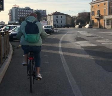
Some segments of the route have allocated space for cyclists in the form of an on-street, painted bike lane of ~1.7 meters. This allows room for some small error and close passing. There is not often congestion (traffic jams) on this route meaning that cyclists can cautiously use roadway space if necessary.
Bibliography
[1] Sicurato, «Sicurato,» [Online]. Available: https://www.sicurauto.it/news/piste-ciclabili-22-in-7-anni-ecco-le-regioni-piu-pedalabili/. [Consultato il giorno 07 08 2021].
[2] TuttaItalia, «Senigallia,» [Online]. Available: https://www.tuttitalia.it/marche/52-senigallia/. [Consultato il giorno 07 08 2021].
[3] Tuttaitalia, «Comuni per fascia demografica,» [Online]. Available: https://www.tuttitalia.it/comuni-per-fasce-demografiche/. [Consultato il giorno 07 08 2021].
Interested in knowing more about Heuristic Evaluation? This project is presented as the final assignment for the course User Experience for Inclusive Cycling in Cities. Check the course to learn further :)


Comments